Calculate Yard Slope for Homeowners: Measure 10 Feet for Drainage
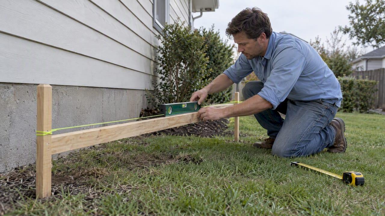
Slope percent equals rise divided by run, times 100. The fastest homeowner method is a 10-foot string run: level the string, measure the drop to the ground in inches, then divide by 120. A 6-inch drop over 10 feet gives a 5% slope, the same figure the IRC uses for soil next to a foundation, while hard surfaces need 2%.
TL;DR:
- Keep the run horizontal and fixed at 10 feet, take readings at several locations, and average them because yard grades rarely stay uniform.
- A board and level works alone but can rock on uneven turf; lasers need steady tripods, while calibrated phone sensors provide only rough checks.
- Hire a surveyor or contractor when structural work depends on the grade or runoff is complex, and confirm permit rules with your local building department.
- Record each reading’s slope percentage and fall direction on a site map, then attach photos of steep areas so contractors price the same project scope.
Table of Contents
- How do you measure yard slope with stakes, string and a line level?
- What other tools can measure a slope?
- How do you convert slope between percent, inches per foot, ratio and degrees?
- What drainage rules should your slope meet?
- How accurate are homeowner measurements, and when should you hire a pro?
- How can you add slope measurements to a virtual property map?
- How do you turn slope data into contractor quotes?
- Why measure slope before planning anything?
- FAQ
- Sources
How do you measure yard slope with stakes, string and a line level?
This is the method we recommend for most homeowners because it needs cheap tools and gives repeatable numbers. A consistent run length is what makes it work: university arboretum guidance notes that measuring slope is commonly a two-person job and that a fixed run, such as 10 feet, simplifies the math and improves repeatability.
Tools you need: two stakes, a ball of string, a line level, a tape measure, a hammer, and a helper or a weight to hold the string taut.
- Drive the first stake at the top of the slope, then measure 10 feet horizontally downhill and drive the second stake.
- Tie the string to the uphill stake, as low as you can while keeping it above the ground along the whole run.
- Hang the line level at the middle of the string and raise or lower the downhill end until the bubble centers. Pull the string tight.
- Measure straight down from the level string to the ground at the downhill stake. That vertical distance is your rise, in inches.
- Divide the rise by 120 (10 feet in inches) and multiply by 100. A 6-inch rise gives 5%.
Ten feet makes the math easy because the run never changes.
Mistakes that throw off your result:
- A sagging string. Pull it tight before you read the level.
- Measuring along the ground instead of horizontally.
- Setting the string at different heights on each stake without noting it.
- Reading the bubble before it settles.
Pro Tip: Wrap a strip of tape around the string at the 10-foot mark and level it against the tape, so you never have to re-measure the run on later passes.
What other tools can measure a slope?
Stakes and string are not your only option. Each of these methods suits a different yard.
- Board and spirit level: Lay a straight board of known length on the ground, lift the downhill end until the level reads flat, and measure the gap under the lifted end. It works alone, but a bumpy lawn can rock the board, so rest it on the high spots.
- Laser level: Set it on a tripod at the top of the slope and read the beam height on a measuring stick at the bottom. One person can do it. Bright sunlight and uneven tripod legs are the usual error sources, and a clear 10-foot or longer run helps.
- Clinometer or phone app: These read an angle directly. University extension guidance describes Abney levels and clinometers as rugged instruments that read percent or angle, and recommends hands-on instruction to master each tool. A phone sensor is fine for a rough check, but calibrate it on a known flat surface first.
- Water hose level: Clear tubing filled with water settles at the same height at both ends. It is inexpensive and accurate over long distances, as long as no air bubbles are trapped.
Whichever tool you pick, use horizontal distance for the run. Surveying practice favors horizontal over slope distance because slope distance is longer and can introduce small errors on steeper ground.
How do you convert slope between percent, inches per foot, ratio and degrees?
Once you have a percent, you can express it in any format a contractor or code asks for. The USGS explains that a 5% slope equals 0.6 inches of fall per foot, or a 1:20 ratio.
Here are a few worked examples:
- 6 inches over 10 feet: (6 ÷ 120) × 100 = 5%.
- 3 inches over 10 feet: (3 ÷ 120) × 100 = 2.5%.
- 1 inch per foot: 12 inches over 144 inches is 8.33%.
Conversion checklist you can copy:
- Percent to inches per foot: percent × 0.12.
- Percent to ratio: 100 ÷ percent gives the “1 in X” number (5% is 1 in 20).
- Percent to degrees: take the arctangent of (percent ÷ 100). Degrees matter mostly for tools that read angles.
- Degrees back to percent: take the tangent of the angle, times 100.
What drainage rules should your slope meet?
Check your local building department for grading requirements. IRC R401.3 requires finished grade to fall at least 6 inches within the first 10 feet from the foundation, which is a 5% grade. Impervious surfaces within 10 feet, such as patios and walkways, must slope at least 2% away from the building.
- Soil next to the house: at least 5% for the first 10 feet.
- Patios, walks and driveways near the foundation: at least 2% away from the walls.
- If a barrier prevents drainage away from the house, ask your local building department or a drainage professional about suitable alternatives.
Poor drainage near a foundation can be a concern. If water pools there, consult a drainage professional about possible solutions, such as regrading or a swale. This swale design guide discusses design considerations.
Check your local building department too, since your jurisdiction may amend the IRC. For related projects, see our guides on retaining wall drainage, driveway slope limits and building a pool on a sloped yard.
How accurate are homeowner measurements, and when should you hire a pro?
Hand tools are good enough for residential planning. The tradeoff is precision: a string line, board or phone will not match surveying equipment, and accuracy depends more on keeping the run length consistent than on how fancy the tool is.
Common error sources include a sagging string, an unlevel tripod, a phone that was never calibrated, and measuring along the ground instead of horizontally. To tighten your numbers, fix the run at 10 feet, take several measurements at different spots, and average them. Slopes are rarely uniform, so a single reading can mislead.

Call a professional surveyor or contractor when structural work depends on the numbers or when drainage is complex. Check with your local building department about any permit requirements. For complicated runoff, engineers establish the flow path first and calculate from a known starting elevation, because applying formulas without a flow direction causes errors.
Pro Tip: Verify any reading by repeating it on another 10-foot run nearby. If the results differ, investigate the cause before relying on either one.
How can you add slope measurements to a virtual property map?
A measurement on paper is only useful if it reaches your plan. We built our tools so you can draw the footprint of a fence, deck, pool or pad on a satellite map.
A simple method works well:
- Sketch the project on the map first, so the dimensions come from the actual lot rather than guesses.
- Mark where you took each 10-foot reading, and write the percent next to it.
- Note the direction of fall. A yard that drops toward the house is a different problem from one that drops away from it.
- Flag the steepest section, since that is where grading, footings or extra labor are likely to add cost.
Our Local project report provides a map-based, site-specific view of the project. For a fence, our Fence Estimator lets you draw the project on a map, while the Deck Estimator helps you plan a deck. For a pool, the Pool Estimator helps you plan the project.
Planning on the map also forces useful questions early. Does the retaining wall sit above or below the steepest reading? Is a swale needed before the footing is poured?
How do you turn slope data into contractor quotes?
Contractors price what they can see. A vague request such as “my yard is sloped” produces padded bids, because every bidder has to guess the worst case. Specific numbers produce tighter, comparable quotes.
Here is a practical sequence:
- Measure the slope at the project location using the 10-foot method, and record the percent and the direction of fall.
- Draw the project on the map with exact dimensions, not rounded ones.
- Pick the estimator that matches the project, such as the Concrete Estimator for a slab or pad, where slope changes the base preparation and the amount of material.
- Add your slope readings and photos of the steepest areas to the project notes.
- Review the estimate range, then submit the quote request so contractors receive the drawing, measurements and photos in one packet.
Because bidders start from the same scope, you can compare their numbers line by line instead of wondering which one assumed a steeper yard. If a contractor finds a different slope on site, you have your own readings to discuss, which makes any change order easier to understand.
Why measure slope before planning anything?
A repeatable 10-foot measurement replaces opinion with a number. That number sharpens estimates for retaining walls, decks and pools, and it shrinks the gap between bids. Take it before you call anyone, and use our guides or site-planning tools for the next step.
— Christian
FAQ
How do I find what a 2% slope is?
A 2% slope drops 2 units for every 100 units of horizontal run. Over 10 feet, the drop in inches equals 2 percent of the run.
How many inches is a 5% slope?
A 5% slope falls about 0.6 inches per foot, according to the USGS. Over a 10-foot run, that adds up to 6 inches of drop.
What are the three formulas for slope?
The standard form is percent slope equals rise divided by run, times 100. You can express the same value as inches per foot by multiplying percent by 0.12, or as degrees by taking the arctangent of rise divided by run.
Can Google Maps show slope?
Map views can give a rough sense of terrain, but they are not a reliable way to measure the grade of a small yard. For drainage decisions, measure on site with a string and line level, or a laser level, so the reading reflects the exact spot.